


Garmin eTrex 20x GPS Device Topo Canada Bundle
This product is no longer available.
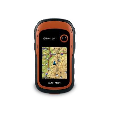
eTrex 20x takes one of the most popular and reliable GPS handhelds and makes it better. Redesigned ergonomics, an easier-to-use interface, paperless geocaching and expanded mapping capabilities add up to serious improvements for an already legendary GPS handheld.
Bundle includes: eTrex 20x, TOPO Canada microSD card, carrying case, belt clip, USB cable, documentation
Features:
- See the Way: eTrex 20x has an enhanced 2.2", 65K color, sunlight-readable display. Durable and waterproof, eTrex 20x is built to withstand the elements. It has an upgraded interface yet retains its legendary toughness to withstand dust, dirt, humidity or water.
- Go Anywhere: With an array of compatible mounts, eTrex 20x is designed for use on ATVs, bicycles, in boats, as a handheld or in your car.
- Go Global: The new eTrex series is the first-ever consumer-grade receivers that can track both GPS and GLONASS satellites simultaneously.
- Add Maps: With its microSD card slot and 1.7 GB of internal memory, eTrex 20x lets you load TOPO 24K maps and hit the trail, plug in BlueChart g2 preloaded cards for a great day on the water or City Navigator NT map data for turn-by-turn routing on roads (see maps tab for compatible maps). eTrex 20x also supports BirdsEye Satellite Imagery (subscription required), that lets you download satellite images to your device and integrate them with your maps.
- Keep Your Fix: With its high-sensitivity, WAAS-enabled GPS receiver and HotFix® satellite prediction, eTrex locates your position quickly and precisely and maintains its GPS location even in heavy cover and deep canyons.
- Find Fun: eTrex 20x supports geocaching GPX files for downloading geocaches and details straight to your unit. Visit OpenCaching.com to start your geocaching adventure.
- Plan Your Next Trip: Take charge of your next adventure with BaseCamp, software that lets you view and organize maps, waypoints, routes, and tracks. This free trip-planning software even allows you to create Garmin Adventures that you can share with friends, family or fellow explorers
Specifications:
Physical & Performance:
- Unit Dimensions: 2.1" x 4.0" x 1.3" (5.4 x 10.3 x 3.3 cm)
- Display size: 1.4" x 1.7" (3.5 x 4.4 cm); 2.2" diag (5.6 cm)
- Display resolution: 240 x 320 pixels
- Display type: 2.2" transflective, 65K color TFT
- Weight: 5 oz (141.7 g) with batteries (not included)
- Battery: 2 AA; NiMH or Lithium recommended (not included)
- Battery life: 25 hours
- Waterproof: yes (IPX7)
- Floats: no
- High-sensitivity receiver: yes
- Interface: USB
- Garmin eTrex 20x Maps & Memory:
- Basemap: yes
- Preloaded maps: no
- Ability to add maps: yes
- Built-in memory: 3.7 GB
- Accepts data cards: microSD™ card (not included)
- Custom POIs (ability to add additional points of interest) yes
- Waypoints/favorites/locations: 2000
- Routes: 200
- Track log: 10,000 points, 200 saved tracks
Additional Features:
- Automatic routing (turn by turn routing on roads): yes (with optional mapping for detailed roads)
- Electronic compass: no
- Touchscreen: no
- Barometric altimeter: no
- Geocaching friendly: yes (paperless)
- Photo navigation (navigate to geotagged photos): yes
- Sun and moon information: yes
- Tide tables: yes (with optional Bluechart)
- Area calculation: yes
- Picture viewer: no
- Custom maps compatible: yes
- Garmin Connect™ compatible (online community where you analyze, categorize and share data): yes