



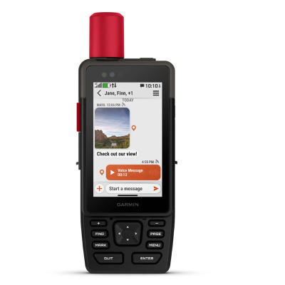


Garmin GPSMAP H1i Plus
- Product Number: 8521 - 8404686
The Garmin GPSMAP H1i Plus is a premium, rugged GPS handheld navigator with a modern design that comes preloaded with maps and built-in inReach® Plus technology1 to stay in touch beyond cellular coverage. It’s time to hit the trails!
Features Overview:
- HYBRID DESIGN OFFERS A 3.5-INCH COLOR TOUCHSCREEN AND PHYSICAL BUTTONS
- EXCHANGE PHOTOS, VOICE MESSAGES AND TEXT MESSAGES WITH AN INREACH SUBSCRIPTION1
- SEND AN SOS MESSAGE TO THE GARMIN RESPONSE℠ CENTER FOR HELP IN AN EMERGENCY (SUBSCRIPTION REQUIRED)
- PRELOADED TOPOACTIVE MAPS, DOWNLOADABLE SATELLITE IMAGERY AND OPTIONAL OUTDOOR MAPS+ CONTENT
- LONG BATTERY LIFE OFFERS UP TO 145 HOURS IN GPS MODE
- MULTI-BAND GPS AND MULTI-GNSS SUPPORT HELPS PINPOINT YOUR PRECISE LOCATION
Feature Overview:
TOUCHSCREEN DISPLAY: The bright, sunlight-readable 3.5-inch color touchscreen has chemically strengthened glass to resist scratches. It is glove-friendly, easy to see and easy to use. Tap, zoom and swipe on the maps to follow your route.
PHYSICAL BUTTONS: The rugged hybrid design also features intuitive push buttons for more versatility when in weather and while wearing gloves. The quick-action button lets users customize functions to their specific needs.
PHOTOS AND VOICE/TEXT MESSAGING: With an active inReach subscription1, send group text messages up to 1,600 characters. You can also exchange photos and voice messages when outside of cellular coverage.
SOS ALERTS: Trigger an interactive SOS message anytime to the 24/7-staffed Garmin Response international coordination center for help in an emergency. This requires an active inReach subscription.
ADVANCED NAVIGATION: Navigate with preloaded TopoActive maps for the U.S., Mexico and Canada — and easy-to-access global maps. See terrain contours, elevations, geographical points and more.
SATELLITE IMAGERY: Download high-resolution photorealistic maps directly to your device via Wi-Fi® technology. Find trails, pick stand locations and parking, create waypoints and more.
Specifications:
General
- Lens Material: chemically strengthened glass
- Dimension: 2.6" x 7.0" x 1.3" (6.7 cm x 17.9 cm x 3.3cm)
- Weight: 10.2 oz (290 g)
- Water rating: IP67
- MIL-STD-810: yes (thermal, shock, water); bare unit only
- Touchscreen: Yes
- Display Type: transflective color TFT
- Display Size: 1.9"W x 3.0"H (4.7 x 7.7 cm), 3.5" diagonal (8.9 cm)
- Display resolution: 282 x 470 pixels
- Battery Type: rechargeable, internal lithium-ion
Battery life
- All Satellite Systems + Multi-band: Up to 145 hours*
- Expedition mode: Up to 840 hours
- Performance messaging mode with 10-min inReach® tracking: Up to 48 hours*
- Expedition mode with 10-min inReach® tracking: Up to 425 hours
- Low-power mode with 10-min inReach® tracking: Up to 135 hours
*Assuming typical use with SatIQ™ technology
Memory/History
64 GB (user space varies based on included mapping)
Interface
- USB-C
- Maps & Memory
- Preloaded maps: yes (TopoActive, routable)
- Ability to add maps: Yes
- Basemap: Yes
- Automatic routing (turn by turn routing on roads) for outdoor activities: Yes
- Map segments: yes (15,000)
- Satellite Imagery: yes (direct to device)
- Includes detailed hydrographic features (coastlines, lake/river shorelines, wetlands and perennial and seasonal streams): Yes
- Includes searchable points of interests (parks, campgrounds, scenic lookouts and picnic sites): Yes
- Displays national, state and local parks, forests, and wilderness areas: Yes
- External memory storage: yes (1 TB max microSD card)
- Waypoints: yes
- Courses: unlimited
- Activities: unlimited
- Activity profiles: Yes
- GPX imports: Yes
- Rinex logging: Yes
Sensors
- GPS: Yes
- Galileo: Yes
- QZSS: Yes
- BeiDou: Yes
- IRNSS: Yes
- Barometric altimeter: Yes
- Compass: Yes
- High-sensitivity receiver: Yes
- GPS compass (while moving): Yes
- Multi-band frequency support: Yes
Daily Smart Features
- Connect IQ™ (downloadable watch faces, data fields and apps): Yes
- Smart notifications on handheld: Yes
- Weather forecasts: Yes
- Weather: Yes
- Compatible with Garmin Messenger app: Yes
- Pairs with Garmin Connect™ Mobile: Yes
- Voice command: Yes
- Noise cancellation: Yes
- Voice assistant: Yes
- Voice notes: Yes
- Garmin Share: Yes
- Passcode: Yes
- Next Word, Auto Complete, Auto Correct: yes (Auto Correct, Next Word, Auto Complete)
Safety and Tracking Features
- LiveTrack: Yes
- Safety siren: Yes
Tactical Features
Compatible with AB Quantum - Garmin: Yes
Ballistics solver: yes (unlock required)
Dual grid coordinates: Yes
Night vision mode: Yes
Outdoor Recreation
- Spoken turn-by-turn directions: Yes
- Area calculation: Yes
- Sun and moon information: Yes
- Geocaching-friendly: yes (Geocache Live)
- Custom maps compatible: yes (500 custom map tiles)
- Picture viewer: Yes
Camera
- Front: 5 MP
- Rear: 8 MP
- Flashlight: Yes
Mapping & Navigation
- Point-to-point navigation: Yes
- TracBack®: Yes
inReach® Features
- Interactive SOS: Yes
- Weather: Yes
- Send and receive text messages to SMS and email: Yes
- Send and receive text messages to other inReach device: Yes
- Send and receive group messages: Yes
- Send and receive photos: Yes
- Send and receive voice messages: Yes
- Send and receive 1,600 character messages: Yes
- Exchange locations with other inReach device: Yes
- LiveTrack: YesVirtual keyboard for custom messaging: Yes
Outdoor Applications
- Compatible with Garmin Explore™ app: Yes
- Garmin Explore website compatible: Yes
- Smart switching between Wi-Fi, Cellular and Satellite with Garmin Messenger app: Yes
- Dog tracking: yes (when paired to compatible dog track system)
Networking & Connections
- Wireless Connectivity
- yes (Wi-Fi®, BLE, ANT+®)