ELA Stewart Lake Loop Canoe Route Map and Guide

All trip information is accurate to our knowledge at the time of posting, and provided for informational purposes only. Map additions or suggestions can be directed to info@wildernesssupply.ca. All images and descriptions are the property of Wilderness Supply.
Trip Details
Type: Canoe or Kayak
Approximate Distance: 20km
Number of Portages: 4
Recommended Time: 1-2 nights
Fees/Permits required: There are no permits required to enter the ELA area by the road listed here, though permits are required for some alternate access points. There are no fees for camping on crown land.

Click through for full interactive google map
Planning
This route requires the topographical map for Feist Lake (52/F13), available from Canada Map Sales at 1007 Century St, Winnipeg. Due to the number of portages a lightweight, kevlar canoe is recommended - these are available for rent. Cell reception is patchy along this route, and we suggest taking a SPOT unit (which is also available for rent) in case of an injury or emergency.
Getting There
The Experimental Lakes Area is located roughly 3 hours east of Winnipeg. Take the Trans Canada Highway past Kenora. The turnoff is to the south of the highway approximately 42 km east of the junction of Highway 17 and 71. Watch for a dirt road on the south side of the highway between the 116km and 122km markers. If you are coming from Winnipeg, this will be just past the Gordon Lake sign.

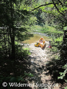
Continue down this road past the railroad tracks until you get to a small bridge. Stop and unload your gear and boat here; just before the bridge there is a short, clear path down to a sandy put-in area.

The Route
Paddle east out of the bay, then head south through Lower Stewart Lake. You will hear the rapids at the first portage before you see them. Pull up to the right just before the rapids - the start of the portage route is marked with a small sign on a tree. When the pathway splits the lower route to the right is muddier, but easier.

First Portage
Head southwest and then southeast through Geejay lake. You will see the red roof of a private cabin in the distance - head straight towards it, as the portage is right in front. The proper pull up is marked with a "Trans Canada Trail" sign, to the left at the mouth the rapids - approach carefully to avoid the current. Note that this portage has two possible ends: during high water those with some whitewater skills can put it at the first access point and continue through some small rapids. Alternately, continue along the path to the second access point directly into Manomin lake.

Second Portage
Head east into Manomin Lake. There is a potential alternate route south into Manomin Lake which extends this trip to an easy 2 nights. Otherwise, continue east towards the third portage. Keep your eye open for the motorboats that are usually pulled up at the start of this portage, as well as many of the other portages on this route.
Third Portage
Head northeast and then north through Winnange Lake. There is a large campsite here that makes a good stop on a 1-night trip or second stop on a 2-day trip - however it's a popular spot, so you may need to share. There are a few good alternate spots to pitch a tent on the island if the main campsite is in use.
Continue north through Winnange Lake. The final portage is located to the left just at the start of the marsh - again, look for the motorboats. From here the portage trail heads right along the shoreline before turning left and heading up the hill for a very steep section not-so-lovingly known as the "Devil's Staircase."

Fourth Portage
If you unload your gear at the start of the trail depending on your canoe's toughness and the water level you may be able to skip carrying your boat the first 100m in by paddling through the marsh and pulling your boat over the beaver dam to the second access point. It is not recommended to attempt this with a loaded canoe, or in a kevlar or fiberglass model not designed to take the extra strain. Once you have all your gear together, proceed carefully up and over the hill. The alternate trail to the right is no easier, and less secure - stick to the main set of stair-like rocks.

The "Devil's Staircase"
Head northwest and then west through Upper Stewart Lake. There is a small channel where there used to be a road at the end of the bay - don't worry if you can't see it at first. Continue all the way to the end of the bay, where a small opening will reveal itself.


Continue west through Railway Bay and back to the bridge. If you want to spend an extra night camping, consider turning south again into Lower Stewart Lake and stopping at one of the first campsites for the night. In the morning you can paddle the short distance to the bridge to collect your car and finish the trip.
Important Notes:
- Always leave a detailed trip plan and estimated time of return with someone back home before embarking on any trip.
- Campsites along this route are not regulated or maintained - camp in established sites and do not build new fire pits. Practice "Leave No Trace" camping, especially in regards to food and human waste.
- Always secure all food and garbage and hang it where it cannot be reached by bears or other rodents during the night.
- Bring a full topographical map and compass even if you have a GPS, and make sure that someone in your group is familiar with how to read them.
- Drowning and hypothermia are real risks even for experienced paddlers. Always wear a PFD when on the water, and keep watch for changing weather conditions.
- If you have questions about this or any other trips, please visit your nearest Wilderness Supply store, where our staff will be happy to provide advice and suggestions!
All paddlers undertake trips at their own risk. Canoeing/kayaking is a potentially dangerous activity, and should not be undertaken unless you are medically able and properly trained. Wilderness Supply has no responsibility for any claims, demands, causes of action, damages, or injuries, whether caused by paddler negligence or any other cause on this or any other provided trip routes. Paddlers should assess both the current conditions and their own skill levels at all times during their trip to take the safest course of action possible. Always leave a route plan and expected time of return with a third party before heading out on a trip, and take along a means of making emergency contact if necessary.