Bloodvein River, Manitoba
The Bloodvein River is a remote, pool-and-drop whitewater river flowing from its source near Red Lake in Northwestern Ontario down to its eventual end in the east side of Lake Winnipeg in Manitoba near the centre of the lake. The Bloodvein has been classified as part of the Canadian Heritage Rivers System to preserve its unspoiled, natural rugged beauty. The Bloodvein certainly represents the Canadian Shield as it slowly tumbles towards Lake Winnipeg through thick pine forests and exposed granite ridges. Given the pool-and-drop nature of the river, the Bloodvein can be paddled by most levels of paddlers as long as they have proper skills to ferry to portage take-outs and put-ins, and of course, have the skills necessary for wilderness travel.
To preserve the river the Manitoba and Ontario governments have set aside the Atikaki Wilderness Park and Woodland Caribou Provincial Park, respectively, which encompass the river corridor and a portion of its drainage basin.
The Bloodvein is a popular river, and often groups can be found paddling the river from spring until fall. However, the river is most popular in July and August, and if paddling outside of those months it is truly possible to paddle the Bloodvein and encounter very few other paddlers.
Access to the Bloodvein can be accomplished in several ways. Most people will paddle the river with the flow ending up in Lake Winnipeg. However, because of the pool-and-drop nature of the river the current for most of the journey is such that it can be paddled upstream. Also, float plane egress can be arranged to exit the river sooner, as several lakes exist along the Bloodvein which are suitable for a float plane to land.
There is no actual road access to the Bloodvein but the river can be accessed via the Gammon River from Walace Lake in Manitoba or close to its source, from Red Lake, Ontario. However, both of these road access options are quite far from the mouth of the river on Lake Winnipeg and make for a long car shuttle. Alternatively, a float plane can be chartered from several locations. Logistically it is easiest to hire a plane from Pine Dock or Matheson Island in Manitoba as you can then paddle back to your waiting vehicle eliminating the need for organizing a car shuttle.
A Typical Trip on the Bloodvein
In September of 2005, Ken and I decided that we really needed to get out for a paddle. However, we could really only organize a week free of commitments. Neither of us were willing to ante up the cash for a float plane, but we were still eying the Bloodvein river using the Gammon river to access it. The statistics were a little daunting; over 250 km of distance, the long and famous Obukowin portages, along with a car shuttle. So in only a couple days we threw together the gear we would need: enough food for a week, ultralight camping gear; and outfitting for my Bell Northwind including a spray skirt, knee pads and a better yoke.

So Day 1 involved about a 3 hour drive from Winnipeg to the campground on Wallace Lake off of Provincial Road 304. From there we paddled the Wanipigow River into Siderock Lake. We decided to paddle instead of the much shorter portage, as we figured the upcoming Obukowin portages would give us plenty of walking that day. From Siderock lake we began the long Obukowin portages toward Obukowin Lake and the Gammon watershed. The Obukowin portages are a series of portages with a couple small ponds in between up, and over the Canadian shield. The portages are worn trails through the bush and require constant attention to make sure you don't wander off. During our trip a beaver had built a dam flooding part of the trail ensuring we would have to do a little bit of navigation to keep on trail. With a fully outfitted boat, and a week's worth of food, we were both wishing we had paid for a float plane, but after a long struggle we reached Obukowin lake. A windy rain set in as darkness began to fall and we decided to set up camp. Both of us were silently nervous as we had only covered under 10 km in our first day, so with the whole Gammon and Bloodvein route in front of us, had we over-estimated our distance capability?

Day 2 started early as we knew we would have to put in an honest day of paddling, or at some point consider turning around if the distance proved too much. We spent the day traversing the upper lakes and channels of the Gammon river system. The wide open lakes proved to be gusty and we passed a couple fishing camps along the way. However, the sun was shinning and we paddled hard eager to prove ourselves to this river.
To increase our distance covered we used kayak paddles in the canoe allowing us to clip along with the double blades. Kayak paddles are an easy, efficient way of paddling a canoe as you get to stroke on both sides and the stern paddler no longer has to do a correction stroke to keep the canoe moving in a straight line. They are prone to drip a little more, and you give up that relaxing style of paddling that comes from using a single blade.
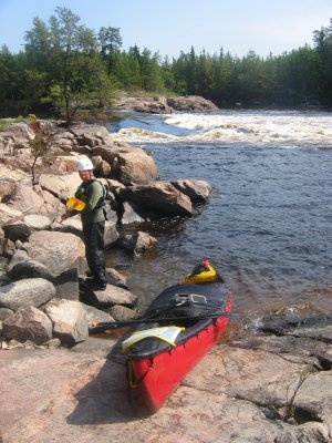
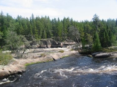
We certainly didn't hit a lot of runnable rapids in the first day and ended up doing more portaging and lining. The Gammon was spectacular, as the soft sandy soil supports gorgeous stands of forest and the medium sized river winds through some narrow channels when it gets squeeze by granite outcroppings.
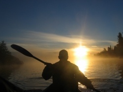
Our first rapid was true to our adventure. I was paddling in the bow of the boat, instructing Ken who to this point had limited whitewater canoe experience. Our first rapid involved a couple maneuvers and then plunging through a medium sized hole. All went smoothly except for our exit out of the hole where the water caught Ken's paddle and snatched it from his hands. This took us over and we ended up swimming, picking up our gear from the swirling end of the rapid. From that point we never flipped again, after running many much more aggressive rapids. It would have been a slow, wet trip if we had flipped in every rapid, as there were over 100 to come.
The long day of paddling allowed us to cover 50 km and were becoming more comfortable with covering the whole distance in our narrow time frame. Our campsite was on a narrow spit of granite stretching into the river with white pines whispering in the wind overhead.
We started to establish a rhythm of breaking camp and paddling long days. Every campsite was gorgeous and were fairly plentiful. We only passed a couple other solo canoeists on the whole trip so we were never competing for campsites. A couple of days into the trip we realized that our 2 and a half butane/propane fuel canisters was a fair underestimation of our fuel requirements. We tried to cook lunch and diners over an open fire, to conserve our now dwindling fuel supply.
Days 3 to 6 went pretty smoothly and we ran lots of rapids and were able to cover our average of 50 km per day. So in the evening of Day 6 we camped around 10 km from our rendezvous with Lake Winnipeg. In the last day the land started to flatten out and deciduous trees started to replace the tall stands of pine from earlier in the trip. Pelicans replaced bald eagles and the rapids became less technical and more straight forward.
On Day 7 we awoke hoping to catch the ferry to the west side of the lake that runs from the Bloodvein Indian Reservation. We were successful and on the ride over met a solo paddler from Coloardo who already had his truck parked on Matheson Island. He generously offered us a ride back to Winnipeg, saving us from initating our plan which was to call Winnipeg for a ride.
The Bloodvein experience left both Ken and I very tired after paddling many long days, but we manged to squeeze the experience including transporation to our one free week at the end of summer. Certainly I would suggest the average paddler to take much more time to do the river. It is well worth enjoying with absolutely breathtaking scenery around every corner.
Written by: Leigh Woltman