


Garmin eTrex Touch 35 GPS Device
Loading...
- Product Number: 4208 - 3362034
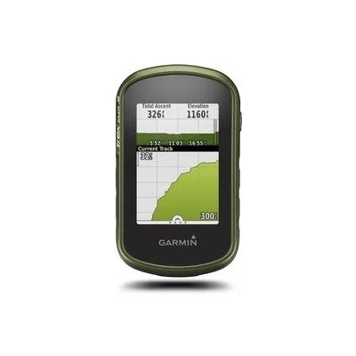
The handheld ETrex Touch 35 has a colour touchscreen GPS/GLONASS with 3-axis compass, barometric, altimeter and more. Compact, rugged and reliable 3-axis tilt-compensating electronic compass, wireless connectivity, with preloaded geocaches and expandable internal memory to hold more maps.
Features:
- 2.6-inch color capacitive touchscreen
- 3-axis tilt-compensated compass and barometric altimeter
- GPS and GLONASS satellites for faster positioning
- 250,000 preloaded geocaches from Geocaching.com
- Extra memory to hold more maps
- GLONASS satellites “lock on” to a position (on average) approximately 20 percent faster than GPS receivers
- MicroSD™ card slot and an expandable internal memory
- Load TOPO maps
- share your waypoints, tracks, routes and geocaches wirelessly
- High-sensitivity, WAAS-enabled GPS receiver and HotFix® satellite prediction, eTrex Touch 35 locates your position quickly and precisely
- Preloaded with 250,000 geocaches from Geocaching.com
- software that lets you view and organize maps, waypoints, routes and tracks
Specifications:
General
- PHYSICAL DIMENSIONS: 2.3” x 4.0” x 1.3” (5.8 x 10.2 x 3.3 cm)
- TOUCHSCREEN: Yes
- DISPLAY SIZE: 1.43" x 2.15" (3.6 x 5.5 cm)
- DISPLAY RESOLUTION: 160 x 240 pixels
- DISPLAY TYPE: 2.6" 65K color TFT
- WEIGHT: 5.6 oz (159 g) with batteries
- BATTERY TYPE: 2 AA batteries (not included); NiMH or Lithium recommended
- BATTERY LIFE: Up to 16 hours
- WATER RATING: IPX7
- HIGH-SENSITIVITY RECEIVER: Yes
- INTERFACE: mini USB
- MEMORY/HISTORY: 4 GB
Maps & Memory
- ABILITY TO ADD MAPS: Yes
- BASEMAP: Yes
- AUTOMATIC ROUTING (TURN BY TURN ROUTING ON ROADS): Yes (with optional mapping for detailed roads)
- MAP SEGMENTS: 4000
- BIRDSEYE: 250 BirdsEye Imagery files
- INCLUDES DETAILED HYDROGRAPHIC FEATURES (COASTLINES, LAKE/RIVER SHORELINES, WETLANDS AND PERENNIAL AND SEASONAL STREAMS): no (additional mapping needed)
- INCLUDES SEARCHABLE POINTS OF INTERESTS (PARKS, CAMPGROUNDS, SCENIC LOOKOUTS AND PICNIC SITES): no (additional mapping needed)
- DISPLAYS NATIONAL, STATE AND LOCAL PARKS, FORESTS, AND WILDERNESS AREAS: no (additional mapping needed)
- EXTERNAL MEMORY STORAGE: yes (32 GB max microSD™ card)
- WAYPOINTS/FAVORITES/LOCATIONS: 4000
- TRACKS: 200
- TRACK LOG: 10000 points, 200 saved tracks
- ROUTES: 200 routes, 250 points per route; 50 points auto routing
Sensors
- GPS: Yes
- GLONASS: Yes
- BAROMETRIC ALTIMETER: Yes
- COMPASS: Yes (tilt-compensated 3-axis)
- GPS COMPASS (WHILE MOVING): Yes
Daily Smart Features
- VIRB® REMOTE: Yes
- SMART NOTIFICATIONS ON HANDHELD: Yes
Safety and Tracking Features
- LIVETRACK: Yes
Outdoor Recreation
- POINT-TO-POINT NAVIGATION: Yes
- COMPATIBLE WITH BASECAMP™: Yes
- AREA CALCULATION: Yes
- HUNT/FISH CALENDAR: Yes
- SUN AND MOON INFORMATION: Yes
- GEOCACHING-FRIENDLY: Yes (Paperless)
- CUSTOM MAPS COMPATIBLE: Yes (100 custom map tiles)
- PICTURE VIEWER: Yes
Connections
- WIRELESS CONNECTIVIT: Yes (BLUETOOTH®, ANT+®)